Exhibit 99.1

TECHNICAL REPORT SUMMARY

FRAC SAND RESOURCES AND RESERVES

KERMIT AND MONAHANS MINES

Winkler and Ward Counties, Texas

Prepared For

ATLAS SAND COMPANY, LLC

By

John T. Boyd Company

Mining and Geological Consultants

Pittsburgh, Pennsylvania, USA


LOGO

Report No. 3871.006

FEBRUARY 2022


               LOGO  

John T. Boyd Company

Mining and Geological Consultants


Chairman  

February 11, 2022

James W. Boyd  

File: 3871.006

President and CEO         
John T. Boyd II     
Managing Director and COO  

Atlas Sand Company, LLC

Ronald L. Lewis  

5918 W. Courtyard Drive #500

Austin, TX 78730

Vice Presidents  
Robert J. Farmer     
Matthew E. Robb  

Attention:


Mr. John Turner

John L. Weiss     

Chief Financial Officer

Michael F. Wick     
William P. Wolf     
Managing Director - Australia  

Subject:


Technical Report Summary

George Cumplido     

Frac Sand Resources and Reserves


Kermit and Monahans Mines


Managing Director - China


Winkler and Ward Counties, Texas

Jisheng (Jason) Han     
Managing Director – South America  

Dear Sirs:

  
Carlos F. Barrera     

Managing Director – Metals

Gregory B. Sparks

  This SK-1300-compliant technical report summary provides the results of John T. Boyd Company’s (BOYD) independent estimate of the frac (proppant) sand resources and reserves for Atlas Sand Company, LLC’s (Atlas) Kermit and Monahans mines as of December 31, 2021.
Pittsburgh         
4000 Town Center Boulevard, Suite 300  

Canonsburg, PA 15317

(724) 873-4400

(724) 873-4401 Fax

jtboydp@jtboyd.com


Denver

(303) 293-8988

jtboydd@jtboyd. com

  We wish to acknowledge the cooperation of Atlas’ management and staff for providing the technical, financial, and legal information used in completing this project. Our findings are based on BOYD’s extensive experience in preparing frac sand resource and reserve estimates used in US Securities and Exchange Commission (SEC) filings, and our knowledge of frac sand mining in Texas and throughout North America.
Brisbane   Introduction

61 7 3232-5000

jtboydau@jtboyd.com


Beijing

86 10 6500-5854

jtboydcn@jtboyd.com

  BOYD was retained by Atlas to complete an independent technical audit of mineral resource and mineral reserve estimates—hereafter referred to as frac sand resource and frac sand reserve estimates—for their active mining operations located near Kermit, Texas (the “Kermit Mine”) and Monahans, Texas (the “Monahans Mine”). Throughout
Bogota  
+57-3115382113  
jtboydcol@jtboyd.com         
www.jtboyd.com     


the report, the Kermit and Monahans mines may also be referred to as the Kermit and Monahans “operations”, “plants”, “properties”, or “facilities”. This report summarizes the results of our resource and reserve estimate and satisfies the requirements for Atlas’ disclosure of frac sand resources and reserves set forth in Subpart 1300 and Item 601(b)(96) of the SEC’s Regulation S-K (S-K 1300). This is the first technical report summary filed with the SEC by Atlas for the Kermit and Monahans mines.

BOYD’s findings are based on our detailed examination of the supporting geologic, technical, and economic information obtained from: (1) Atlas provided files, (2) discussions with Atlas personnel, (3) records on file with regulatory agencies, (4) public sources, and (5) nonconfidential BOYD files. Our analysis was performed to obtain reasonable assurance that Atlas’ frac sand resource and reserve statements are free from material misstatement. This report provides an independent estimate of the frac sand resources and reserves underlying the Kermit and Monahans controlled properties. The basis for these estimates is BOYD’s recent volumetric estimation of the resources and reserves.

This report provides a summary of primary information and is supported by a more comprehensive report that includes commercially sensitive and competitive information that was not included in this summary report at the request of the client. The Economic Analysis and resulting present value (PV) estimate in this report were made for the purposes of confirming the economic viability of the reported sand reserves and not for the purposes of valuing Atlas or its assets. Internal Rate of Return (IRR) and project payback were not calculated, as there was no initial investment considered in the financial model.

Weights and measurements are expressed in US customary units. Unless noted, the effective date of the information, including estimates of frac sand reserves, is December 31, 2021.

Property Description and Control

Atlas has two mines located within the Permian basin of Texas. In June 2018, Atlas received a Mine Safety and Health Administration (MSHA) identification number (41-05367) for the Kermit Mine, and in July 2018 they received Monahans’ MSHA identification number (41-05359). Both mines have been operating continuously since that time.


JOHN T. BOYD COMPANY


2


The Kermit operation, in Winkler County, Texas, is located approximately seven miles northeast of the town of Kermit and is a surface frac sand mining and processing facility, located on approximately 5,826 “gross” acres (the “Kermit Property”) of which 5,341 “net” acres are controlled (leases and fee-owned). After applying requisite mining offsets, approximately 4,521 acres (or 78% of the property) have been explored and are considered as either mineable resources or reserves.

The Monahans operation is a surface frac sand mining and processing facility, located on approximately 32,224 “gross” acres (the “Monahans Property”) which is entirely leased by Atlas. After applying requisite mining offsets, a total area covering approximately 11,187 acres (or 35%) of the Monahans Property has had exploration work completed, with dense enough drill hole coverage to be considered as frac sand resources and reserves, as of the date of this report. Atlas has also completed a reconnaissance-level of exploration drilling and sampling work on an additional 9,575 acres (or an additional 30%) outside of the resource and reserve areas of the Monahans Property. This “exploration target” area has a more widely spaced drilling density than the aforementioned resource and reserve areas, however drilling and testing indicates this portion of the deposit exhibits similar characteristics, both in thickness and frac sand quality. The mine, located in Ward and Winkler counties, Texas is approximately three miles northeast of the town of Monahans.

Mining and related activities for the Atlas operations are predominantly regulated by the Texas Commission on Environmental Quality (TCEQ). The Kermit operation has a Permit-By-Rule number of 148113, and their current New Source Review (NSR) air pollution control permit is renewable in 2028. The Monahans operation has a Permit-By-Rule number of 148572, and their current New Source Review air pollution control permit is also renewable in 2028. Other permits held for the operations include Stormwater, Above Ground Storage Tank, Aggregate Production Operation, and a septic permit. A SPCC plan (spill prevention plan) is also active at each operation. There are no formal state or federal reclamation plans or permits required for the operations.

Atlas participates in a voluntary Candidate Conservation Agreement with Assurances (CCAA) for the Dunes Sagebrush Lizard (DSL). The agreement, which Atlas signed in January 2021, lasts for 23 years. Their voluntary participation in the CCCA effectively mitigates DSL regulatory risk for the Atlas Kermit and Monahans mining operations. Atlas can either set aside acreage for DSL habitat or contribute cash to continue participating in the CCAA. Atlas holds significant sand acreage outside of their current resources and reserves that would be able to be contributed or set aside for the CCAA,


JOHN T. BOYD COMPANY


3


allowing them to continue mining operations, even if the DSL is listed as an endangered species.

The general location of both mines is provided in Figure 1 following this page.

Physiography

The Kermit Property and the Monahans Property are situated within the Texas Great Plains physiographic province, a region encompassing much of northwestern and western Texas. The surrounding areas generally consist of desert valleys covered with windblown sheet and dune sands, high plains covered with thick alluvium (the Llano Estacado or Staked Plains), or plateaus consisting of thin carbonate-based soils (the Caprock Escarpment). The two properties encompass a majority of the active dune complexes found in this area. The plateau areas, typically covered by a weathering-resistant caliche (a hardened natural cement of calcium carbonate that binds other materials—such as gravel, sand, clay, and silt), may abruptly stand up to 1,000 ft above the plains. Much of the region may be covered by various types of desert scrub grasses, sages, yuccas, junipers, shin oaks, and mesquites.

Regional Geology

Quaternary-aged sand formations are present across the surface of much of the area in and around the Kermit and Monahans properties. Both properties contain active sand dune complexes, consisting of large and open dunes exposed at the surface, which are constrained by the Llano Estacado Caprock to the east, and caliche outcrops towards the west. Much of the surrounding areas contain surficial deposits consisting primarily of windblow sheet sands, ancient dunes, and dune ridges.

Local Stratigraphy

Surficial geologic units overlying the properties and surrounding areas are predominantly Quaternary age unconsolidated deposits, ranging from windblown sheet sands and dunes to alluvial sands, silts, clays, and caliche. Origins of these deposits are believed to be a combination of eroded bedrock material from the southern Rocky Mountains, and locally eroded Ogallala Formation sandstone. As portions of the southern Rockies were eroded via weathering, particles were carried to the Pecos River. Ancient flooding events of the Pecos River resulted in the suspended particles being deposited into flood plains.


JOHN T. BOYD COMPANY


4


LOGO


5


Once flood waters receded, winds took over, drying and further transporting these particles into the western Texas region.

The Llano Estacado Caprock Escarpment marks the eastern-most extent of the surficial sand deposits. Winds transporting particles into the area are thought to have collided with the escarpment, which slows the velocity of the particles and drops particles out of suspension, where they have accumulated over time. Winnowing processes have caused some degree of particle sorting to occur. Due to the mechanisms and long distances of particle transport, sand grains were abraded and rounded as they reached their current locations.

These processes resulted in the formation of the Kermit and Monahans dune fields, covering an area of approximately 5-10 miles wide, and 60 miles long, extending primarily through Winkler and Ward counties in west Texas. The present-day dune system and surrounding sheet sands are largely vegetated, however the active dune fields, on which Atlas’ Kermit and Monahans operations are located, contain no discernable overburden materials except for sparse areas of vegetation and roots that are removed during processing. The Kermit and Monahans deposits are mineable from the surface down to the total defined depths of the deposit.

Quaternary unconsolidated dune deposits cover the subject properties generally ranging in thickness from 60-ft to over 100-ft, which is above average thicknesses seen in other surficial sand deposits of the area. A generalized stratigraphic chart of the geologic units in Ward and Winkler counties, Texas is presented in Figure 2.


System


Series


Geologic Unit

   Pleistocene /    Sheet and Dune
Quaternary    Holocene    Sand
   Pleistocene    Unconsolidated
      Alluvium
Neogene    Pliocene    Ogallala Formation

Figure 2: Generalized Stratigraphic Chart, Surficial

Deposits of Ward and Winkler Counties, TX

Quaternary Sheet and Dune Sands

The Kermit and Monahans properties are uniformly covered by Quaternary sheet and dune sands generally consisting of fine-to medium-grained quartz sand grains mixed with varying degrees of silts, calcareous sands, and caliche nodules. Surficial sand


JOHN T. BOYD COMPANY


6


deposition may range in thickness from less than 10 ft of windblown sheet sands to hundreds of feet of dune sands. Unconsolidated alluvial deposits consisting of pebble-to cobble-sized limestone and chert nodules overlain by silts are found to the east of the properties.

Ogallala Formation

The Ogallala Formation is predominantly comprised of weakly cemented to unconsolidated fine-to medium-grained sands, which may be silty and calcareous in places. A caliche caprock is frequently exhibited, which resists weathering and forms ledges. Thickness of this formation has been recorded up to 550 ft.

Frac Sand Geology

Frac sand is a naturally occurring, high silica content quartz sand with grains that are generally well-rounded and monocrystalline. The main difference between frac sand and other sands is that frac sand grains are relatively pure in composition, consisting almost entirely of quartz; other sands have numerous impurities that may be cemented to the quartz grains. The pure quartz composition of frac sand grains, along with being well-rounded and spherical in shape, gives these sands the characteristics (crush strength, high acid solubility, low turbidity) that are sought after by oil and gas producers for use in developing wells.

Exploration

Atlas contracted Westward Environmental Inc (Westward) to perform a series of drilling and sampling programs on the Kermit and Monahans properties, which occurred over the period June 2017 through March 2018.

The drilling and sampling program was executed in equivalent manner on each property as Westward supervised the field work and sampled each hole. Holes were drilled using a rotosonic drill rig, and each hole was sampled on 5-ft increments from the surface. Westward geologists and geological technicians determined the terminus of the sampling interval of a hole, as drilling would be stopped when the amount of sand in a recovered interval was neither the first nor second most abundant material present in a given sample interval. All drilled intervals were geologically logged, photographed, and sampled in duplicate. One set of samples was retained by Atlas for archival purposes, while the other set of samples was sent to a lab for grain size analyses and proppant sand quality testing.


JOHN T. BOYD COMPANY


7


In 2017, an initial drilling and sampling program utilized widely spaced exploration drill holes, with nominal spacing of 3,000-ft to 4,500-ft between drill holes (one hole drilled per section of controlled property), in order to determine the depth and lateral extent of the sand deposits across the Kermit and Monahans properties. There were 36 holes drilled and sampled on the Kermit Property in June and July 2017. There were 53 holes drilled and sampled on the Monahans Property from June to August 2017. Sample analyses were performed by PropTester in Cyprus, Texas and FracTAL in St. Paul, Minnesota.

An infill drilling program was subsequently initiated in March 2018 to increase geologic confidence on each of the subject properties. This consisted of completing an additional 25 drill holes on the Kermit Property and 27 drill holes on the Monahans Property. Upon completion of the infill drilling programs, each property now had a nominal 1,500-ft drill hole spacing within their respective initial mining areas, which provided enough geoscientific information to be able to classify the infill drilled areas as Proven Reserves. A summary of both drilling campaigns is presented in Table 1.


Table 1: Atlas Drilling and Sampling Program

 
     Rotosonic Holes Drilled and Sampled  
     Initial*      Infill**      Combined  

Kermit Property

     36        25        61  

Monahans Property

     53        27        80  


Total

     89        52        141  


*

Drilled and sampled June to August 2017

**

Drilled and sampled March 2018

Frac Sand Reserves and Quality

This technical report summary provides an estimate of frac sand reserves for Atlas’ Kermit and Monahans mines in accordance with the requirements set forth in S-K 1300. These estimates were independently prepared by BOYD and utilized in conjunction with information provided by Atlas including: a life-of-mine (LOM) plan, the relevant processing, economic (including estimates of capital, revenue, and cost), marketing, legal, environmental, socio-economic, and regulatory factors for each operation.

Estimates of mineral resources and reserves are always subject to a degree of uncertainty. The level of confidence that can be applied to a particular estimate is a function of, among other things: the amount, quality, and completeness of exploration data; the geological complexity of the deposit; and economic, legal, social, and


JOHN T. BOYD COMPANY


8


environmental factors associated with mining the resource/reserve. BOYD used the definitions provided in S-K 1300 to describe the varying degree of certainty associated with the estimates reported herein.

Estimates of frac sand resources are subdivided to reflect the different levels of geological confidence into measured (highest geologic confidence), indicated, and inferred (lowest geologic assurance). Upon application of modifying factors that include adjustments for mining loss, processing loss, and economic factors, a measured resource may be converted to either a proven or probable reserve, while an indicated resource may only be converted to a probable reserve. An inferred resource may not be converted to a reserve, due to the lower level of geological confidence.

A mineral reserve is the economically mineable part of a measured or indicated mineral resource, which includes diluting materials and allowances for losses that may occur when the material is mined or extracted. Estimates of mineral reserves are subdivided to reflect geologic confidence, and potential uncertainties in the modifying factors, into proven (highest assurance) and probable.

In this report, the term “frac sand reserves” represents the tonnage and quality of product sand that will be available for sale after washing and drying the run-of-mine (ROM) sand. When material variations in thickness, depth, and/or sand quality occur between drill holes, the allowable spacing distance is reduced. The following drill hole spacing criteria were determined by the Qualified Person and used in this report to define the sand resources within Atlas’ properties:


Resource    Spacing Requirement (ft)  

Classification

   (Nominal Maximum)  

Measured

     1,500  

Indicated

     2,500  

Inferred

     5,000  

BOYD’s estimate of frac sand reserves for the Kermit and Monahans mines as of December 31, 2021, total 368 million saleable product (i.e., greater than 140-mesh and less than 40-mesh in grain size) tons. There are 198 million tons underlying the Kermit Property and 170 million tons underlying the Monahans Property.


JOHN T. BOYD COMPANY


9


Table 2 presents the estimated frac sand reserves by product mesh size, reserve classification, and mineral ownership status for the Kermit and Monahans mines:


Table 2: Atlas Sand Company, Kermit and Monahans Reserves (As of December 31, 2021)

 
     Tons (000) By Classification and Mesh Size      Total         
     Proven      Probable      By Mesh Size         

Control

     40/70        70/140        Total        40/70        70/140        Total        40/70        70/140        Total  

Kermit Operation


Owned

     79,019        61,269        140,288        —          —          —          79,019        61,269        140,288  

Leased

     28,580        24,433        53,013        2,599        2,232        4,831        31,179        26,665        57,844  


Total

     107,599        85,702        193,301        2,599        2,232        4,831        110,198        87,934        198,132  

Monahans Operation


Leased

     72,021        46,826        118,847        32,041        19,057        51,098        104,062        65,883        169,945  

Projecting sales volumes of approximately 5 million tons per year per operation, the expected LOM of the Kermit operation is plus 40 years and the Monahans operation is plus 34 years. This longevity only considers the estimated Proven and Probable Reserves as shown above. Substantial additional saleable product will be available as the in-place resources and other exploration target areas are converted to reserves.

The additional in-place resources consist of the Measured and Indicated resources that have not been formally included in a mine plan by Atlas but have adequate geoscientific information to be converted to reserves in the future. The Inferred Resources consist of areas that generally need additional exploration drilling on a closer spacing to classify them as a Measured or Indicated Resource. These resources, estimated at 1.665 billion tons (398 million tons Kermit, 1,267 million tons Monahans), represent the in-ground material prior to applying any mining and processing losses. As additional mine planning is developed and additional drilling is performed on the resource areas of the properties, the in-place material may be converted to reserves by factoring in the mining and process loss.

Concerning the frac sand quality of the properties, PropTester and Lonquist performed API RP-19C/ISO 13503-2 tests on composite samples created from sample material collected during the drilling programs on the Kermit and Monahans properties. A composite of the entire depth drilled from each hole selected was created, and for each composite sample, the testing labs created 40/70-mesh and 40/140-mesh product


JOHN T. BOYD COMPANY


10


samples which were then analyzed for the full suite of API RP-19C/ISO 13503-2 proppant sand tests.

Overall, this extensive testing indicated that a relatively uniform range of crush values exist through the entire depth of the deposit, except for one or two intervals where the caliche interval was not completely removed before performing the crush tests. These caliche intervals were about 1,000 psi less than all other intervals, and as such were not included in the summary quality data.

Combining the extensive crush testing conducted with the API testing performed on the composite samples, Atlas has completed a comprehensive review of grain characteristics for each of the reserve areas within each property. The data indicate little variability within the overall mineable deposit on each property.

Sample testing results are summarized in Table 3 below for each product size analyzed within each property:


Table 3: Proppant Performance Test Results for Kermit and Monahans

     Average ISO/API Test Results By Product Size and Property
     40/70-mesh    40/140-mesh*,**

Test

   Kermit    Monahans    Recommended
Specification
   Kermit    Monahans

Sphericity

   0.7    0.7    ≥ 0.6    0.7    0.7

Roundness

   0.8    0.7    ≥ 0.6    0.7    0.7

Acid Solubility (%)

   1.1    0.9    ≤ 3.0    2.6    1.6

Turbidity (NTU)

   15.0    7.0    ≤ 250    15.0    13.0

K-Value (000 psi)

   7 - 8    7 - 8    —      10 - 11    10 - 11


*

100-mesh proppant sand material currently does not have an API/ISO specification.

**

Test results were for a single 40/140-mesh product.

The extent to which the frac sand reserves may be affected by any known geological, operational, environmental, permitting, legal, title, variation, socio-economic, marketing, political, or other relevant issues has been reviewed as warranted. It is the opinion of BOYD that Atlas has appropriately mitigated, or has the operational acumen to mitigate, the risks associated with these factors. BOYD is not aware of any additional risks that could materially affect the development of the frac sand reserves.

Based on our independent estimate and operations review, we have a high degree of confidence that the estimates shown in this report accurately represent the available frac sand reserves controlled by Atlas, as of December 31, 2021.


JOHN T. BOYD COMPANY


11


Operations

Mining

The Kermit and the Monahans mines both employ dredging as the primary sand extraction method. Most of the mineable area at both locations has minimal overburden and vegetation; as such, sand excavation normally begins at the surface throughout most of the mine plan area. BOYD has reviewed the LOM plans for both operations and they appear to be representative of the Reserve tonnage estimates reported herein. Both mines operate continuously, 24/7.

Processing

Each plant has a nominal capacity of approximately 5.0 million tons per year of finished product. The Kermit Plant was commissioned in July 2018 and the Monahans Plant was commissioned in October 2018.The predominant frac sand products produced at the operations include 40/70-mesh and 100-mesh (40/140-mesh) products. Since the commissioning of the wet plants in 2018 through the end of 2021, the actual process yield for both plants is approximately 90%. In general, for every 100 tons of ROM material fed into the plant, 90 tons of saleable product is produced prior to entering the dry process plant. It should be noted that these actual process yields are slightly different than the process yields used to estimate the entire Reserve. The Reserve estimate utilized the average of all of the corehole laboratory analysis data for the entire property.

Once the material has been mined from the pit, it proceeds to the processing plants as follows:


Wet Process Plant- ROM material from the dredge is pumped to the wet plant and the greater than 40-mesh and less than 140-mesh sand and silt material is removed. The wet plant has a nominal capacity of 1,500 tph and typically operates in the 900 tph to 1,300 tph range to allow for fluctuations in feed.


Dry Process Plant- The wet 40/140-mesh material produced by the wet process plant is dried and screened into finished products. The dry plant capacity is 750 tph and typically produces 600 tph to 620 tph depending on residual moisture and screening configuration to maximize 40/70-mesh product yield. An on-site quality laboratory samples and monitors production and shipping sand quality daily.


JOHN T. BOYD COMPANY


12


Storage and Loadout- Finished products are stored in silos and gravity loaded from under the silos into highway trucks for transport to the customer. The Atlas loadout operates 24 hours per day, 7 days per week every day of the year.


LOGO

Figure 3: Kermit Plant with Truck Loadouts


LOGO

Figure 4: Monahans Plant with Truck Loadouts


JOHN T. BOYD COMPANY


13


Infrastructure

The Kermit Operation is supplied three-phase power by Oncor Electric Company (Oncor), headquartered in Dallas. A substation (Chevenne) accesses Oncor’s 138 kV line and steps voltage down to a 12.5 kV line which delivers power to the plant approximately 3.8 miles northeast of the substation. Monahans has a similar power distribution scheme with Oncor supplying power from a substation approximately

1.3 miles south of the plant. The incoming voltage to the plant is 12.5 kV.

Line natural gas is supplied to both plants by West Texas Gas (WTG). Natural gas line capacity into both plants is 16,000 standard cubic feet (mscf)/day.

Plant process water is recycled within the plants and is pumped from the dredge pond reservoir. Additional makeup water is obtained from a wellfield containing 14 water wells having an approximate capacity of 1,600 gallons per minute (gpm) at Kermit, and 21 water wells having an approximate capacity of 2,500 gpm at Monahans. The wells at both plants are only utilized as a backup water supply.

On-site facilities at each site include a scale house, office, shop, and a quality laboratory located in the dry process plant. The surface facilities currently located at the mine are well constructed and have the necessary capacity/capabilities to support both of the operations. Operational preference may constitute the upgrading of some existing facilities if the operation expands in the future.

Financial Analysis

Market Analysis

Permit submissions for horizontal oil and gas wells in the Permian Basin indicate a continuation of strong drilling ahead. Utilizing data from Baker Hughes and The Railroad Commission of Texas (RRC of TX), the total number of permits filed per average annual working rig for 2021 is tracking at multi-year highs as evidenced in the chart below. For


JOHN T. BOYD COMPANY


14


calendar year 2021, there was a total of 4,413 permit submissions with an average 227 horizontal rigs active in the Permian Basin (ratio of 19.5).


LOGO

Figure 5: Permian Basin HZ Permit Submissions vs. Rigs

Rig counts in the Permian Basin are up approximately 64% as of year-end 2021 versus 2020. This has led to increased production for both crude oil and natural gas. Over the same time-period, crude oil production (barrels per day) and natural gas production (thousand cubic feet per day) in the Permian Basin are up 13% and 16%, respectively. Both Permian Basin daily crude oil production and daily natural gas production continue to exceed pre-pandemic peaks and reach new records. As of year-end 2021, crude oil production in the basin is nearly 5.0 million barrels per day while basin natural gas production stands at 19.8 billion cubic feet per day.


LOGO

Figure 6: Permian Oil Production and Natural Gas Production


JOHN T. BOYD COMPANY


15


Consequently, with increases in production and well completions, activity at frac sand mines in the region have increased. According to MSHA, operating hours for the third quarter of 2021 for Permian Basin frac sand mines were up 36% since year-end 2020.


LOGO

Figure 7: Permian Wide In-Basin Mine Operating Hours (Quarterly)

According to industry reports, all but one frac sand mine in the Permian Basin is currently fully operational. However, total in-basin mine operating hours are still about 45% below their historical peak. Generally, mine operating hours correlate well with crude oil and natural gas production and drilling and uncompleted (DUC) well data. Current frac sand production in the Permian Basin is estimated to be nearing prior peak production of about 70 million tons leading to stable pricing in the basin. BOYD anticipates stable frac sand pricing with a slight upside bias due to potential supply chain disruptions and high commodity input costs.

Economic Analysis

BOYD reviewed historical sales, production costs, and other financial data pertaining to the Kermit and Monahans operations. In addition, we were provided production, sales, and cost projections for the subject operations.

Cash Cost of Goods Sold (COGS) include operating costs (mining, wet processing, dry processing, product loadout, maintenance, and other related costs), royalty, property taxes and insurance, and final reclamation.

Cash flow projections for the Kermit and Monahans operations have been estimated utilizing LOM production and sales volume projections, historic operating costs, and


JOHN T. BOYD COMPANY


16


CapEx estimates supplied by Atlas. Atlas provided current sand pricing (as of the report date) utilized for revenue projections.

The net present value (NPV) estimates for Kermit and Monahans were made for purposes of confirming the general economic viability of the reported frac sand reserves and not for purposes of valuing Atlas or its assets. Internal rate-of-return (IRR) and project payback were not calculated, as there was no initial investment considered in the financial model. All values are as of January 1, 2022, for both operations. The intent of this exercise is to demonstrate that the operations generate positive cash flows (based on a 10% discount rate), on a pre-tax basis, that supports the statement of frac sand reserves herein.

A Discounted Cash Flow-Net Present Value (DCF-NPV) on a pre-tax basis, using a discount rate of 10% was calculated utilizing projected cash flows for the LOM. The DCF-NPV values used mid-year discounting and all cash flows were on a constant dollar basis. The estimated pre-tax DCF-NPV at a 10% discount rate for the Kermit operation is approximately $1,201 million. The estimated pre-tax DCF-NPV at a 10% discount rate for the Monahans operation is approximately $1,183 million. The combined pre-tax DCF-NPV at a 10% discount rate is approximately $2,384 million.

Other Relevant Information

Registrant and Purpose

This technical report summary was prepared for Atlas in support of their disclosure of frac sand reserves for the Kermit and Monahans mines in accordance with S-K 1300 Regulations.

Atlas is a private, US-based mining company headquartered in Austin, Texas. Atlas’ first shipments from the Kermit Mine were in July 2018 and from the Monahans Mine in October 2018. Atlas provides in-basin frac sand to the surrounding energy drilling market within the Permian Basin. All of Atlas’ products are trucked to the surrounding energy projects from both of their Permian based mines. Atlas’ website is found at www.atlassand.com.

Terms of Reference

Atlas initially retained BOYD to complete an independent technical report for both mines (Kermit and Monahans) which was issued in December 2018 (BOYD Report No. 3871.000). Subsequently, Atlas retained BOYD to prepare a SEC-compliant technical report summary to support their disclosure of frac sand reserves following S-K 1300


JOHN T. BOYD COMPANY


17


requirements. Our objective is to utilize the original report as a basis and incorporate additional information that we have reviewed into compiling an updated compliant technical report summary contained herein. The estimates within this report are adjusted to reflect an “as of” date of December 31, 2021.

The results of our review, presented in report form herein, were prepared in accordance with the disclosure requirements set forth in Subpart 1300 and Item 601(b)(96) of the SEC’s Regulation S-K. The purpose of this report is threefold: (1) to summarize available information for the subject mining properties, (2) to provide the conclusions of our 
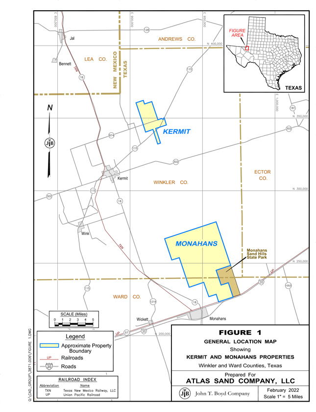
technical audit, and (3) to provide a statement of frac sand resources and reserves for the Kermit and Monahans mines. This is the first technical report summary filed by Atlas for the mines.

BOYD’s findings are based on our detailed examination of the supporting geologic, technical, and economic information provided by Atlas in formulating the estimates of frac sand resources and reserves disclosed in this report. We independently estimated the frac sand resources and reserves from first principles based on third-party exploration information provided to BOYD.

We used standard engineering and geoscience methods, or a combination of methods, that we considered to be appropriate and necessary to establish the conclusions set forth herein. As in all aspects of mining property evaluation, there are uncertainties inherent in the interpretation of engineering and geoscience data; therefore, our conclusions necessarily represent only informed professional judgment.

The ability of Atlas, or any mine operator, to recover all of the estimated frac sand reserves presented in this report is dependent on numerous factors that are beyond the control of, and cannot be anticipated by, BOYD. These factors include mining and geologic conditions, the capabilities of management and employees, the securing of required approvals and permits in a timely manner, future sand prices, etc. Unforeseen changes in regulations could also impact performance. Opinions presented in this report apply to the site conditions and features as they existed at the time of BOYD’s investigations and those reasonably foreseeable.

This report is intended for use by Atlas subject to the terms and conditions of its engagement agreement with BOYD. The agreement permits Atlas to file this report as a technical report summary with the SEC pursuant to Subpart 1300 and Item 601(b)(96) of Regulation S-K. Except for the purposes legislated under US securities law, any other uses of or reliance on this report by any third party is at that party’s sole risk. The


JOHN T. BOYD COMPANY


18


responsibility for this disclosure remains with Atlas. The user of this document should ensure that this is the most recent disclosure of frac sand resources and reserves for the Kermit and Monahans mines as it is no longer valid if more recent estimates have been issued.

Expert Qualifications

BOYD is an independent consulting firm specializing in mining-related engineering and financial consulting services. Since 1943, BOYD has completed over 4,000 projects in the United States and more than 90 other countries. Our full-time staff comprises mining experts in: civil, environmental, geotechnical, and mining engineering; geology; mineral economics; and market analysis. Our extensive experience in frac sand resources/reserve estimation and our knowledge of the subject property, provides BOYD an informed basis on which to opine on the frac sand reserves available at the Atlas mines. An overview of BOYD can be found on our website at www.jtboyd.com.

The individuals primarily responsible for this audit and the preparation of this report are by virtue of their education, experience, and professional association considered qualified persons as defined in Subpart 1300 of Regulation S-K.

Neither BOYD nor its staff employed in the preparation of this report have any beneficial interest in Atlas, and are not insiders, associates, or affiliates of Atlas. The results of our resource/reserve estimate and subsequent audit were not dependent upon any prior agreements concerning the conclusions to be reached, nor were there any undisclosed understandings concerning any future business dealings between Atlas and BOYD. This report was prepared in return for fees based upon agreed commercial rates, and the payment for our services was not contingent upon our opinions regarding the project or approval of our work by Atlas and its representatives.

Principal Sources of Information

Information used in this assignment was obtained from: (1) Atlas files, (2) discussions with Atlas personnel, (3) records on file with regulatory agencies, (4) public sources, and (5) nonconfidential BOYD files. The basis for this report is the previously compiled BOYD technical report (BOYD Report No. 3871.000 issued in December 2018) which provided an independent estimate of frac sand reserves for the Kermit Mine and the Monahans Mine as of the commencement of mining in 2018.


JOHN T. BOYD COMPANY


19


Additional information was provided by Atlas including:


Financial forecasting models.


Historical information, including:


Production reports and reconciliation statements.


Financial statements.


Product sales and pricing.


Mine plans.


Site plans.


Operational data.

The data and work papers used in the preparation of this report are on file in our offices.

Site Visits

A personal inspection of the Atlas operation was made by two of BOYD’s senior geology and mining staff—both qualified persons and co-authors of this report—on April 4, 2018. The site visit included: (1) observation of the active mining operations, (2) a tour of the mine site’s surface infrastructure, and (3) a tour of the process plant and truck loadouts. BOYD’s representatives were accompanied by Atlas’ General Manager who openly and cooperatively answered questions regarding, but not limited to: site geology, mining conditions and operations, equipment usage, labor relations, operating and capital costs, current and proposed processing operations, and frac sand marketing. The predominant significant operational change to the operations since the time of our site visit has been the transition to a dredge mining scheme. The dredges were not in operation at the time of the visit.

Reliance on Information Provided by the Registrant

In the preparation of this report we have relied, without independent verification, upon information furnished by Atlas with respect to: property interests; exploration results; current and historical production from such properties; current and historical costs of operation and production; and agreements relating to current and future operations and sale of production.

BOYD exercised due care in reviewing the information provided by Atlas within the scope of our expertise and experience (which is in technical and financial mining issues) and concluded the data are valid and appropriate considering the status of the subject properties and the purpose for which this report was prepared. BOYD is not qualified to provide findings of a legal or accounting nature. We have no reason to believe that any material facts have been withheld, or that further analysis may reveal additional material


JOHN T. BOYD COMPANY


20


information. However, the accuracy of the results and conclusions of this report are reliant on the accuracy of the information provided by Atlas.

While we are not responsible for any material omissions in the information provided for use in this report, we do not disclaim responsibility for the disclosure of information contained herein which is within the realm of our expertise.

Effective Date

The frac sand reserves presented in this technical report summary are effective as of December 31, 2021. The report effective date is December 31, 2021.

Units of Measure

The US customary measurement system has been used throughout this report. Tons are dry short tons of 2,000 pounds-mass. Unless otherwise stated, all currency is expressed in constant 2022 US Dollars ($).

Interpretation and Conclusions

Findings

Based on our independent technical review and geoscientific study of the Kermit and Monahans mines, BOYD concludes:


Sufficient data have been obtained through the site exploration and sampling program and mining operations to support the geological interpretations of seam thickness, grain size distribution and API quality for the portions of the sand underlying the controlled property. The data are of sufficient quantity and reliability to reasonably support the sand resource and sand reserve estimates in this technical report summary.


Estimates of proppant sand reserves reported herein are reasonably and appropriately supported by technical studies, which consider mining plans, revenue, and operating and capital cost estimates.


The 368 million product tons of frac sand reserves (as of December 31, 2021) estimated for the two mines are economically extractable under reasonable expectations of market volumes and pricing for proppant sand products, estimated operation costs, and capital expenditures.


There are no other relevant data or information material to the Kermit or Monahans mine that is necessary to make this technical report summary not misleading.


JOHN T. BOYD COMPANY


21


Significant Risks and Uncertainties

As with any mining project there are certain inherent risks associated with the overall operation of a facility. Atlas has sufficiently mitigated operational risk through obtaining sufficient geologic sampling information and analysis. Additionally, Atlas has engineered the processing plant to include parallel duplicate process circuits which significantly increases plant availability. However, it should be noted that frac sand is generally marketed exclusively to the energy industry which has historically been a volatile industry.

BOYD notes that the ability of Atlas, or any mine operator, to recover all of the reported frac sand reserves is dependent on numerous factors that are beyond the control of, and cannot be anticipated by, BOYD. These factors include mining and geologic conditions, the capabilities of management and employees, the securing of required approvals and permits in a timely manner, future sand prices, etc. Unforeseen changes in regulations could also impact performance. Opinions presented in this report apply to the site conditions and features as they existed at the time of BOYD’s investigations and those reasonably foreseeable.

Respectfully submitted,

JOHN T. BOYD COMPANY

By: /s/ John T. Boyd II

John T. Boyd II

President and CEO


JOHN T. BOYD COMPANY


22